
LAANC Further Coordination: Tips and Tricks
As a Part 107 Pilot, you are aware that you will need to check your airspace prior to flight. There will be times where authorization will be needed, either through a LAANC enabled provider or through Dronezone.
If you have never done an authorization request through Dronezone, it is not overly complicated. Some people will make it sound like it is and will make it overly complicated for themselves. I’ll create a separate blog about Dronezone and submitting authorizations here soon. What you should know is that as of this date, May 15, 2024, the FAA is experiencing delays in reviewing/granting authorizations through Dronezone. The current wait times are:
East Regional Service Center: 3-4 weeks

Central Regional Service Cener: 2-3 weeks
West Regional Service Center: 3-4 weeks
Due to this delay, my recommendation to you is to submit for further coordination through your LAANC enabled provider. I personally like using Aloft Air Control, but there are others out there.
The downsides to doing this are the following:
1. You are limited to selecting only 1 day.
2. You must give a minimum of 72 hours.
a. Do NOT include weekends/ holidays in your timeframe calculation.
b. If they have not acted on it by the time the 24-hour mark hits prior to your requested authorization time, the system will automatically cancel it. This is not a denial, just a cancelation.
3. You are limited to 5 per day.
4. Radius can’t exceed 100 miles.
5. Local ATC does not the ability to make any changes to it, unlike Dronezone.
Now for the upside:
1. Request will go directly to the local ATC, not the Regional Service Center.
2. Greater chance of getting approved, if submitted correctly.
Here are some tips that will help you get it approved:
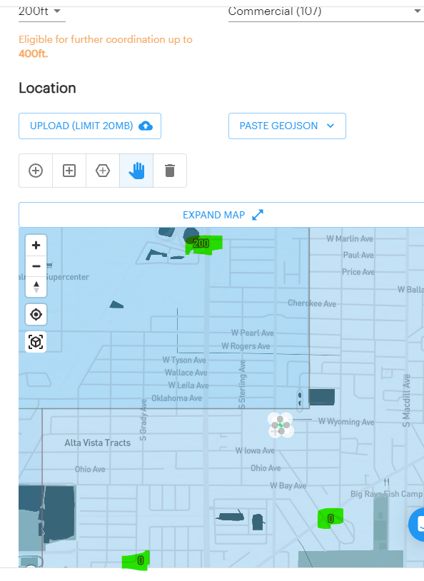
-When submitting for the further coordination, make sure that you are not using the automatic grid box that is created for you. The larger the area, the more pause for concern you will give the approving authority. Request only the area that large enough for what you need to do. Here are some examples using a home inspection:

Automatic grid created by Aloft Air Control
Actual area needed and requested
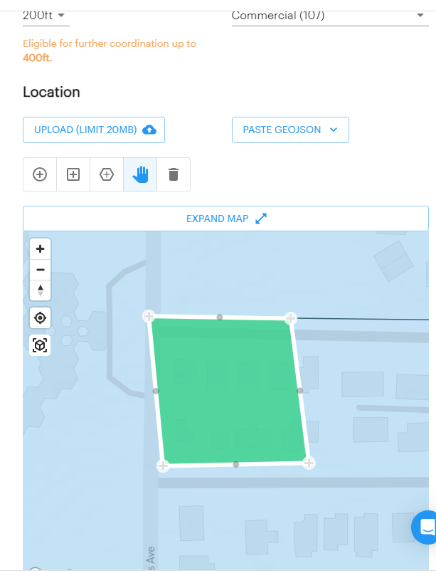
Close up of actual area needed/requested

Safety Justification area
-On the last page prior to submitting, you will have a box labeled “Safety Justification”. Here is where you are going to want to say what you are going to do to make sure that it is a safe flight and what mitigations/processes you have in place. The one that I use is the following:
“Highest altitude gained is 100' AGL for no more than 2 min to capture an overview of the property
-50'-75' to capture orbital images (3-5 min)
-remainder of flight is done at roof level or below
-Pilots monitor local air traffic at all times and use visual observer when necessary
-Local ATC is contacted prior to inspection as well as when inspection is completed
-Local ATC will be contacted immediately in the event of an emergency/fly-away
-Will follow any other safety recommendations that are provided”
Depending on the complexities of the project that you are going to do, some of the justifications may need to be expanded a little bit. For example, if you are going to map a 90 acre area and your flight planning shows a 25 minute flight (or less depending on the drone) at 390’, it would look like this:
“-Highest altitude gained is 390’ for 20-30 minutes to capture mapping images
--Pilots monitor local air traffic at all times and use visual observer when necessary
-Local ATC is contacted prior to inspection as well as when inspection is completed
-Local ATC will be contacted immediately in the event of an emergency/fly-away”
It’s as simple as that. Believe it or not, the people reviewing/approving these want to get through them as quickly as possible. They don’t need to know that you will have a Visual Observer located by the oak tree on the grassy knoll that is near the 4th utility pole at an altitude of 15’ so that he can monitor over the boulder that is 25’ away in a Northeastern direction from waypoint 25. All they want to know is that you will use a Visual Observer if it’s necessary.
Now, if you have more than 1 within that general area, I would make the box large enough to encompass all the inspections that you have within that 0’ grid. I would then make sure to add in the justification section, in addition to the above, that you have “x” number of inspections (enter the address for each one), that the area needed for flight is less than a 500’ radius from the center of the property, and that you will repeat the process of notification for each location. This should allow for you to get more than one location approved while only having to submit it once.
Bonus Tip:
If you are being told by the app that you can get auto approval for “x” number of feet, but then get denied, your box is too big. Make it smaller and keep it within your grid lines so that it gets the auto approval.

Auto approval denied due to extending over the grid line into a 0’ grid
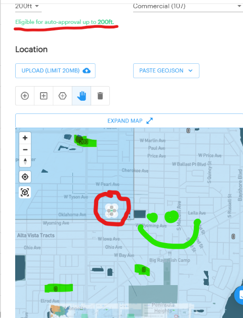
Auto approval granted due to smaller request area
Hope that you find this helpful